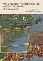
A travel map covering Northeastern United States. The states of Massachusetts, Rhode Island and Connecticut are fully covered. Also included are the southernmost areas of Vermont and New Hampshire, southeastern New York, northern New Jersey and the northeast of Pennsylvania.
The map is designed on indexed 10 km hexes, differentiates between terrain types and includes both road and rail networks as... [click here for more]
The long awaited return of A Dirty Dozen Battlemaps Vol 3 is back and this time we've forgone the pdf format and upgraded to NEW 4K images! I've made this title in JPG as well as WEBP format for that tasty zoomable imagery! Thanks again for all your support and remember, if you look up and fly the bird to the sky, maybe you'll show up in a future issue! ... [click here for more]
We are back with another Dirty Dozen Battlemaps for use with any modern system. These 12 high quality maps are in 3840 x 2160 resolution for vtt usage. All maps are made with and without a hexgrid overlay to allow you to use your own or add a smaller hex inside for more precise movement. Thank you again for your support and have a great year. ... [click here for more]
A Dirty Dozen Battlemaps is a compilation of 12, easy to use maps for modern tabletop gaming. All twelve maps include both gridded and clean copies in 3840 x 2160 size. A pdf and zipfile containing the jpg images are both included with purchase. Thank you very much for your time and support. ... [click here for more]
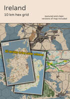
A travel map of Ireland. The map covers whole of Ireland, including Northern Ireland and a small part of the Argyll and Bute lieutenancy of Scotland.
The map is designed on indexed 10 km hexes and differentiates between several terrain types. Both road and rail networks as well as major waterways, large ports and airports are included for your convenient and safe travel. There are a total of 178 settlements... [click here for more]
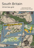
A travel map covering South Britain. The map covers Wales south of Penygroes-Corwen line and England south of Stoke-Boston line as well as Calais and the surrounding French coast.
The map is designed on indexed 10 km hexes, differentiates between terrain types and includes both road and rail networks as well as major waterways, largest ports and airports - both civilian and military. 203 settlements... [click here for more]
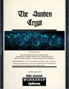
The Sunken Crypt
INTRODUCTION
Where the worlds break, and the light descends. The darkness encroaches within the ever-descending tunnel. Where the hidden crypt lays – hope dwindles and then disappears.
THIS ADVENTURE is for Novice/Adept characters. The module is written for Symbaroum, starting in Thistle Hold and exploring in Davokar Forest and leading to The Sunken crypt.
The... [click here for more]
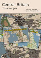
A travel map covering Central Great Britain. The map covers Wales north of Penygroes-Corwen line, England north of Stoke-Boston line and Scotland south of Edinburgh as well as most of Northern Ireland and parts of Ireland surrounding Dublin.
The map is designed on indexed 10 km hexes and differentiates between several terrain types. Both road and rail networks as well as major waterways, large ports... [click here for more]
Enjoy this series of 20 + Isometric maps inspired by the Weatherstone Adventure site as described in the Forbidden lands Game Masters Guide. ... [click here for more]
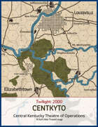
The map for CENTKYTO is a travel map for use with Twilight:2000 4th edition by Free League Publishing. It uses the standard 10km hexes and covers much of Kentucky as well as portions of Indiana, Ohio, Virginia, and West Virginia. Included is a poster-sized PDF, a PNG, as well as JPGs optimized for FoundryVTT and Roll20 with detailed instructions on how to align the grids.
... [click here for more]